


There’s a phrase often heard in maritime circles: the ocean is a big place to hide.
For a country like India — that ocean spans more than two million square kilometres of Exclusive Economic Zone, critical sea lanes carrying over 90 percent of our trade by volume, offshore energy assets, fisheries, submarine cables, and some of the world’s busiest shipping corridors — that isn’t poetry. It’s policy.
And policy, increasingly, is being shaped by technology. After all, watching it all, in real time, day and night, is no small task.
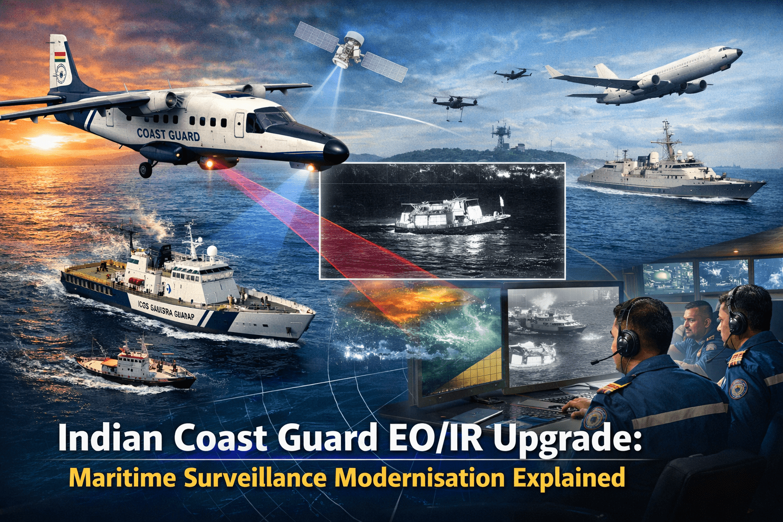
That is why the recent decision to equip the Indian Coast Guard’s Dornier fleet with advanced Electro-Optical/Infra-Red (EO/IR) systems is far more than a technical upgrade. It is a structural shift in how India sees, interprets, and secures its maritime domain.
And when you place this alongside the ₹2,300 crore contract signed with Hindustan Aeronautics Limited for eight new Dornier aircraft, a bigger picture emerges. The new aircraft are the brawn — modern airframes, glass cockpits, extended endurance.
The EO/IR retrofits are the brain — giving the entire fleet, old and new, a uniform, high-fidelity sensory layer. Together, they are building a surveillance grid that will likely define India’s maritime posture well into the 2040s.
One strengthens the fleet’s muscle. The other sharpens its vision.
Together, they redefine how India watches its seas.
Giving the Workhorse a New Pair of Eyes
Indian Coast Guard has long relied on the Dornier 228 as its tactical aviation backbone. The aircraft is reliable, cost-effective, and well-suited for low-altitude coastal patrol. But maritime surveillance in 2026 is no longer about spotting vessels in daylight.
Electro-Optical sensors provide high-resolution daylight imagery capable of identifying small boats, reading vessel markings, and verifying suspicious movement patterns.
Infrared sensors, however, are the real force multiplier. They detect thermal signatures — engine heat, human presence, fuel transfers — even in complete darkness or heavy haze.
In practical terms, this means a wooden dhow operating without AIS in the Arabian Sea at 2 a.m. is no longer invisible. A smuggling attempt using low-profile boats under monsoon cloud cover is harder to conceal. A person adrift in a life raft at dusk becomes detectable through thermal contrast.
This upgrade transforms the Dornier from a visual observer into a 24/7 intelligence asset.
A Human Story: Lakshadweep and the Value of Thermal Vision
In January 2026, a Dornier aircraft was scrambled from Kochi to evacuate a critically ill patient from Agatti Island in Lakshadweep. The crew rapidly converted the aircraft into a makeshift air ambulance and flew through challenging conditions to save a life.
Now imagine a similar scenario unfolding at twilight, in turbulent weather. With advanced EO/IR capability, the aircraft can detect heat signatures on an unlit airstrip, identify ground activity, and safely approach in degraded visibility.
This is where technology meets human consequence. Maritime surveillance is not only about grey-zone competition or counter-smuggling; it is about search and rescue, medical evacuation, and disaster response in one of the world’s most climate-exposed regions.
As cyclones intensify and extreme weather events increase in frequency, thermal and all-weather imaging becomes a humanitarian asset, not just a security one.
The Strategic Backdrop: A More Contested Indian Ocean
The Indian Ocean Region is no longer a passive transit corridor. Piracy off the Horn of Africa has resurfaced intermittently. Drone-enabled smuggling networks are emerging.
State-backed fishing fleets operate in ambiguous patterns. Subsea cable infrastructure — carrying nearly 95 percent of global internet traffic — has become a strategic vulnerability.
In this environment, visibility equals leverage.
The Coast Guard operates below the threshold of war but above routine law enforcement.
It is in this grey space that EO/IR capability becomes critical. Small, deniable, or unflagged platforms are precisely the kinds of targets that evade radar but cannot easily mask heat signatures.
The Dornier, equipped with EO/IR and linked via secure data networks, becomes a node in a broader maritime domain awareness grid that includes the Navy, coastal radar chains, and the Information Fusion Centre – Indian Ocean Region (IFC-IOR).
Where a decade ago surveillance meant reporting sightings after landing, today it means streaming real-time imagery into a joint operational picture.
Integration in Action: Regional Cooperation
During exercises like Exercise DOSTI-17 involving India, Maldives, and Sri Lanka, coordinated maritime patrols demonstrated how aerial assets support regional stability.
Imagine a simulated oil spill detected at night. An EO/IR-equipped Dornier can map the spill’s thermal boundaries, transmit high-resolution imagery to surface vessels, and guide pollution response ships directly to the densest impact zones.
This aligns directly with India’s SAGAR vision and the broader MAHASAGAR doctrine — maritime security as a shared regional responsibility.
In such settings, the Dornier ceases to be a national asset alone; it becomes a cooperative surveillance platform.
Environmental Security: Pollution Response Goes Thermal
Pollution control is a core Coast Guard mandate. During exercises like NATPOLREX and RPREX-25, aircraft are used to identify oil slicks and chemical anomalies.
Thermal sensors detect subtle temperature differences between oil films and surrounding seawater — especially at night when visual detection is limited.
When paired with new pollution control vessels such as ICGS Samudra Pratap, this capability dramatically shortens response times.
The environmental dividend of EO/IR is often underappreciated, but in a country with expanding offshore infrastructure and coastal economic corridors, rapid detection prevents billion-rupee ecological damage.
Operator Training and the Human Factor
Technology without trained operators is inert.
The Coast Guard has been steadily enhancing training at its aviation facilities, including advanced sensor management and data interpretation modules. Pilots are no longer just aviators; they are ISR managers.
Sensor operators must interpret thermal imagery, distinguish false positives from real threats, and coordinate live feeds with command centres.
Human factors — fatigue management, cognitive workload, real-time decision-making — are increasingly central to mission success.
The shift is doctrinal: from flying patrols to conducting intelligence missions.
Budget Context: Smart Modernisation
India’s overall defence modernisation spending continues to prioritise maritime capability amid expanding sea-based trade exposure. Within this framework, the Coast Guard’s upgrades represent a cost-effective force multiplier.
Retrofitting EO/IR systems onto existing Dorniers extends fleet viability toward 2040 without wholesale replacement.
Combined with new HAL-built aircraft featuring over 70 percent indigenous content, the Coast Guard achieves fleet standardisation at a fraction of full acquisition costs.
This is incremental modernisation done strategically.
The Next Frontier: AI, Data, and Automation
The future of maritime ISR lies not just in better cameras but in smarter analytics.
Artificial intelligence and machine learning are increasingly capable of automated target recognition. Instead of a sensor operator manually scanning hours of footage, AI algorithms can flag anomalous vessel behaviour, detect suspicious loitering, or identify heat signatures inconsistent with declared activity.
By 2030, automated cueing systems could reduce detection times dramatically. However, this introduces new challenges: data overload, cybersecurity vulnerabilities, and the need for secure bandwidth.
Protecting EO/IR feeds from interception or manipulation becomes as important as capturing them.
Platform Evolution and Industrial Continuity
The Dornier platform itself continues to evolve. Civilian variants such as the Hindustan-228 demonstrate industrial commitment to the design ecosystem. While amphibious configurations are being explored in civilian contexts, the broader takeaway is platform longevity.
For the Coast Guard, this means a stable, upgradable airframe capable of integrating future sensor suites, communications upgrades, and potentially unmanned teaming capabilities.
The EO/IR procurement is therefore not an endpoint; it is a foundational layer.
A 2030 Outlook
By 2030, maritime traffic through the Indian Ocean is projected to rise substantially alongside offshore energy expansion and blue economy initiatives.
Climate volatility will increase SAR frequency. Grey-zone tactics will become more technologically sophisticated, incorporating unmanned surface vessels and low-cost drones.
In such a scenario, persistent aerial surveillance backed by AI-enhanced EO/IR systems will be indispensable.
The Coast Guard’s Dornier fleet — modernised, networked, and sensor-enhanced — is positioning itself for precisely that future.
Final Reflection
The ocean remains vast. But invisibility at sea is becoming harder to sustain.
With advanced EO/IR systems, the Indian Coast Guard is not merely upgrading aircraft; it is redefining how India watches its maritime frontier.
The combination of human skill, indigenous aerospace manufacturing, regional cooperation, environmental stewardship, and emerging AI integration signals a force transitioning from reactive patrols to proactive, intelligence-driven security.
In a region where the line between peace and provocation is often blurred, clarity of vision may be the most decisive advantage of all.
